Wednesday, 10 September 2014

The Big Blue - Pacific Ocean Crossing, Part I

We had been held hostage in Palau by the US Postal Service for too long, despite not receiving our package – a new inverter, our visa stamps told us it was time to go. After indulging in a huge variety of western foods, loads of spectacular diving and getting to know the cruisers who had washed ashore here and might never leave, we packed our clean washing, bid a hearty farewell to Sam's Tours and the Royal Belau Yacht Club and headed for the east passage.

Contrary to the weather forecasts that we were reading before leaving Palau, we were rocketing south and east and within 2 days we were being treated like royalty by the sea and enjoying the 2 kt east setting current at 40 degrees longitude. Combine this counter current (so named because it runs opposite to the predominant current which sets slowly with the west bound trade winds) with 15-20kts of westerly winds and we were making an amazing 160nm a day which helped lift our spirits on this 2000nm journey to the Solomon Islands. The trip was not without its perils though; we were sailing through a low-pressure system that was forming into a tropical low further north. This meant that we were experiencing lots of squalls, some that we could see forming hours in advance and others that had the rigging singing before we know what was upon us. Most packed some hefty winds of up to 35kts, with rain and then they whipped up the seas often creating some mighty uncomfortable swell conditions. We used the wind vane steering feature on our auto pilot which made for some seriously lazy sailing, as our rudder would turn the boat when the wind shifted (which was extremely often and up to 1800 in the squally conditions) so we didn't have to continually gybe, which was handy when only one of us was on watch.

We spent the first few days getting into some sort of rhythm, with our 3 hour rotating shifts. It was certainly hard to wake up at 4am in a squall to take the helm. But there were bright features like the unspoilt sunrises, light glimmering on the horizon for the first time and spreading a pink blush with each minute that passed. We also had 'Ginger Beard' pay us a visit – a small brown finch with a burnt orange chest that sat on our jib block 400nm from the nearest land to have a snooze. He didn't like it much when I went to pat him and gave me a little nip on the finger. But we talked of the weather and philosophy together nonetheless. He bemoaned the strong westerly wind that kept him from traveling in that direction and I explained the synoptic chart. He nodded and chirped along. And it was a balm to a lonely soul to have such a visitor on those long solo shifts. These sea birds are such amazing creatures. To be able to survive that far from land when they were obviously not sea hunting birds and could not gain nourishment from diving for and eating fish.

The sky ablaze for a spectacular sunset

At 2am on day 5 the heavens opened and sent a torrent of rain that would have had Noah running for his raincoat and gumboots. The rain turned our deck into a swimming pool, ably caught to fill our water tanks. The 6 hour long deluge ended and took with it our spirits and the wind. But as the grey day emerged we saw that we had chipped away at our total passage distance by almost one third.

Day 6 marked the end of our fresh beef stores, we had been spoiling ourselves with beef stews, curries and stroganoff, the memory of Palau lingering. The morning was wet and windy, and spirits may have been dark indeed if not for a visit by Ginger Beard and his girlfriend Red. They snuggled on the captain's seat and got some shuteye after their long journey. After their rest they were quite sociable and we had pats and they sat on my finger. Quite sweet really.

Ginger beard, docile and enjoying a back scratch

Through the driving rain I could see a pod of dolphins having a right party in our bow wave and the swell. I imagine they did not want to pop their noses out of the ocean for too long, otherwise they might get a cold from the rain. The sea temperature was 29C, while the rain and wind made for a nippy time out of our nice protected cockpit.

Conditions? Well we had some reasonable swell, up to 3m and buffeting us from any which angle. It made for an uncomfortable trip and had me slinking into corners with a green tinge taking notable shape on my face. Hugh's long hours of studying the historical weather patterns and daily viewing of the counter current location on the US NOAA (National Oceanic and Atmospheric Administration) website had really paid its dues. Averaging 6 kts of boat speed plus 2-3kts of favourable current meant that we were getting through the long isolated ocean part of the journey at pace. The wind was always blowing, at between 10-20kts, but the direction varied almost by the minute. Relying on our wind vane steering made life a bit easier.

Day 8 saw the end of the low pressure system and therefore the strong winds. The wind was being extremely temperamental and only routing near squally storms could we gain some wind to propel us forward. The wind was so light and variable that the sails would flap and the boom would bang, while the chop from the swell would roll the boat from side to side. The easing up of the wind did not correlate to a more comfortable ride. So using the motor we would make some distance and sail when the wind decided to join us. We were also slowly making a bit of southerly heading and were approaching the unattractive equator and its notoriously hot and wind-free conditions.

A few fish caught made for some lovely fresh dinners and I managed to stay below long enough to cook a cake one day which we gobbled up with custard and canned peaches. Meal times were definitely a punctuation point in the day and something to look forward to. Unfortunately while attempting to make little Spanish mackerel crumbed nuggets my hand got splashed by some jumping boiling oil and I spent the next few hours in the cockpit with an ice pack on my hand, thankfully barely a mark was there within a couple of days.

So what did we do to pass the time? Well, I was engrossed in the Harry Potter series on audio, while Hugh was lost in the 18th Century aboard some historical ships while listening to the Patrick O'Brian nautical series on audio as well. He would wander about the boat and make random ye olde English sayings, raising top-gallant sails and accusing me of being a (land) lubber at times when a sheet was not pulled just so. The start of the sail was too rough to do anything more taxing than listen to music or books. As the time wore on I was able to spend more time below making some tasty meals. 5pm marked the daily 'sundowners' event, which for me consisted of soda and cordial, while Hugh had a cold beer. With the sun down, it was time for our daily emails via the HF. So I stayed up top and steered while Hugh patiently worked the propagation on the radio to try and get a signal so we could receive weather and other inspiring messages from land folk. Hughs sister was sending us daily quirky and funny quotes from English literature from yesteryear which was always a great read.

On day 10 we bid the counter current adieu as it began to sweep northeast, weakening before disappearing below the surface entirely. Unfortunately our daily miles had dropped significantly to around the 100nm mark. The wind was still being fluky, but we were strategically planning our proposed arrival at Kapingamarangi Atoll, 250nm from the nearest atoll and 400nm from its mother-state island of Pohnpei (part of the Federate States of Micronesia), to ensure that we arrived at the best time of the day to make the tricky reef entry without incident. The atoll is a roughly squashed circular shape, an encircled lagoon ringed by reef with spotted sand bars located 1.5m above the high tide mark. We had some pretty poor information about the place and our maps left a lot to be desired.

The full moon and a spring tide would make for ideal entry conditions to the lagoon and on Day 12 we were 25nm away at 7am. It was a steady sail north to the atoll and we were getting very excited and apprehensive about our intended stopping point. We did not know if the locals were friendly (and were hoping not to have the 'welcoming' given to some Spanish explorers to the region – where they were all killed) or even if our boat would be able to cross the reef entry. But we thought we ought to give it a shot and visit one of the most isolated places on earth. Land-ho! It crept from below the horizon 8nm away; tall, dense groupings of trees, our anticipation mounting. Once we got closer we were faced with a long line of breaking waves over a shallow reef boundary (enough to give a sailor a nervous twitch). But then we spotted the channel, a route through the coral boundary that had been blasted to allow the entry of the tri-yearly cargo ship. Some nervous moments and we had made it through the channel, we were in the lagoon!

1200nm, 12 days at sea and this was our first sighting of land. Paradise found!


10/9/2014

----------
radio email processed by SailMail
for information see: http://www.sailmail.com

Saturday, 6 September 2014

Staying Connected

Keeping in touch with friends and family and getting information is harder than when living on land. Sometimes it can be your only contact with the outside world. Sometimes it keeps you sane and importantly, safe!

We knew that it would be important to be able to obtain regular weather information while we were at sea. It would be paramount when on passages as we would be outside of internet, mobile phone and often VHF radio (short distance radio) contact of anyone. When you are 3 days from land, it is heartening to know that you are not sailing straight into the storm of the century or that you should get moving because one is nipping at your heels. We were lucky that our boat had recently been used for blue water cruising and that the gear was reasonably up-to-date.

Ever since Guglielmo Marconi made the first transmission from Galway to Newfoundland in 1901, sailors have been making use of radio communication. Harnessing technology honed in the first and second World Wars, the High Frequency radio (HF, known as Single Side Band to our US friends) is reliable and a great communication tool for remote travellers.

Our boat already had a HF radio fitted, enabling us to contact people via radio sometimes hundreds of miles away, the only requirement was that the recipient also had an HF radio with a suitable receiving antenna. This meant that we could contact the Volunteer Marine Rescue (VMR) stations in Queensland and Charleville Radio (a large radio installation in inland Australia) if we were in serious trouble and were making a mayday call. The boat also had fitted a Pactor modem which enabled data, in very V E R Y slow increments to be emailed from our computer via the HF radio. We signed up to a great service managed out of the United States called Sail Mail. This organisation asks for a yearly subscription fee of $250 and in return connects us to its myriad of receiving stations throughout the world to send our messages on, even when we are thousands of miles from land or another boat.


The excitement of receiving email while at sea is hard to compete with!
Our Sailmail subscription also included connection to a weather service operated by saildocs. The information in the weather messages was drawn from historical data as well as current high and low pressure systems building, so the weather predictions were extremely accurate (on the Australian east coast) where there is high monitoring of conditions and less so in area where there was minimal monitoring (most of Asia). We would review weather predictions up to 3 weeks ahead of a passage to see what was trending and also if there was anything changing that could show signs of dangerous weather. The crossings of the Gulf of Carpenteria and the Arafura Sea were great examples of very strong weather systems moving through (driven by the trade winds), but while they were strong they were consistent and we were able to pick our windows to make the safe crossings. Generally we would receive daily and 5 day forecasts while we were in northern Indonesia, because once again, we were experiencing some very strong wind and sea conditions on a daily basis.

So we were able to gain some reliable weather information via the sailmail service. The weather packages come in a concise file (known as a GRIB file) and it takes some practice to understand what the symbols and colours all mean, but the darker the colour and the more ticks on the wind arrows mean a stronger weather system. When there is little wind, I would call the picture an image of ‘pick-up sticks’ because it was just a collection of sticks dropped in no discernible pattern...the only humour I could find at times like those.


weather file - the picture on the left shows 'stuff all wind' with light blue
colouring, the picture on the right shows a tropical low bringing 40kt
winds shown with the darker red colouring and multiple ticks on the
direction arrows

We also regularly sent messages to family via the HF mail system to let them know we were ok. The service was limited, as it only sent text data (no pictures or attachments) and we only had a certain number of minutes per week. This restriction could be excruciating as the modem runs at the speed of your old household dial up system (complete with the sounds) circa 1997 and it could take up to 30 minutes to get the right connection on the HF radio dial, dodging through used frequencies and interference. This could be extremely frustrating when you are pinned into the nav station while the weather outside is throwing the boat around and inducing some serious seasickness.

Most of our time in Indonesia the Internet was inadequate to send emails, so we relied on the HF mail service even when we were in port. As we moved west to Malaysia, Thailand and then north to the Philippines we were able to get reliable internet coverage. We bought SIM cards in each country  (sometimes multiple cards because the company coverage varied depending on our location) at a rate of about $7 a week we could be on email, Skype and Facebook and be speaking to friends and family as if we were just around the corner. We also subscribed to the Australian Governments ‘smart traveller’ email system which sends out security alerts for the places you have signed up for. This would be useful to know if there was political strife in a country/ island that we were about to travel to, ahead of time. But getting used to this kind of connectivity was going to be interesting in the months ahead as we spent up to 20 days at sea at a time with nothing but HF mail and our salt crazed imaginations for company.

The BBC World Service is also broadcast for 2 hours each day (1 hour in the morning and 1 hour in the evening) which we could pick up on the HF radio in South East Asia. So we were able to keep in tune with events of the outside world. It was interesting how much I looked forward to these 1 hour segments, often just to listen to the strange special stories that their reporters submerged themselves in. As we did not have access to local television, this was as close as we got to any kind of news stream. While we were in Malaysia, we were lucky enough to be able to tune into English language radio stations on the FM radio, however this was usually pop music and information targeted at the lowest common denominator. Once we made it further east to the Pacific, we could hear the Australian news and stories booming in over Radio Australia. Initially it was really interesting to hear people on remote Pacific Islands telling their stories, until the Australian Federal Government cuts to the ABC meant that the segments were all but eliminated and replaced with Radio National stories. Reasonably interesting for us as we were missing a bit of Australiana, but I imagine less interesting to the islanders who were their intended listenership.

While we were in the company of other boats we would use our VHF radio to stay in contact when within 20nm of each other. We used this regularly when we were travelling for a passage to make sure everyone is still ok and to keep track of anyone who was having trouble or would be arriving later than expected. All boats sail at different speeds depending on the sail configuration, the design of the boat and those sailing it, so more often than not there could be between 1-2 days varying in arrival times of different boats at a harbour for a 400nm passage. Other ways to stay in touch for longer passages would be to use the HF radio at scheduled times on pre-arranged channels (referred to as a ‘net’) to catch up on everyones whereabouts and also to forward weather information if necessary. When we were sailing in April from Sydney to Darwin, we ‘met’ cruisers on the net that were 1000nm ahead of us giving tips on good anchorages and weather systems they had experienced. We did not meet some of the voices on this net for 3 months until we arrived in Darwin at the great Woodstock of cruising in July. This informal radio relationship gave us a great opportunity to meet other cruisers who had 20,000nm of experience as they had already sailed half-way around the world and could help us learn the tips of the cruiser life.

We opted out of the SatPhone option providing phone and internet contact while at sea, connecting you to satellite systems. The initial outlay is quite expensive and because we already had the HF radio we were well covered for that kind of communication. We do know other people who have SatPhones and think they are great and very reliable, but you do pay for the convenience.

Via our sailmail we were able to send a position report to another group called YoTreps who logged all of our positions and placed them on a map, so that our family and friends could see our location. That was always a nice feature because people often don’t know where Taka Bonerate in Indonesia is, so putting a pin on a map made the information more visual. There were a number of bugs in the system and Hugh decided that he wanted to make a better platform for us to report our location and got busy coding. After many hours tapping away at the keyboard and some involvement of our friends as handy guineapigs, keelscape has become our new way of mapping our location.


So for budding cruisers out there we highly recommend sailmail over the HF radio and meeting other like minded cruisers on radio nets, because what else have you got to do while in passage but have a chat on the radio? Also try this website for logging your position and keeping your family notified of your location.

Sunday, 24 August 2014

Dive Log - Palau

Below is a collection of dive logs from some of the dive sites that we visited during our time in Palau. To start off with, the area is a marine national park and the waterways, sea life and environment are protected here such that removal of any specimen or artefact is prohibited, as is damaging any of the reefs. The protection mantra is repeated at the tour companies and on your national park pass. Sailing boats are required to have a multitude of permits depending on where in Palau the yacht is and people must carry a national park pass if they are to partake in any water based activities. The money is reported to go to managing the park islands and picnic areas, moorings for dive boats and improving the infrastructure for aquatic activities. The sea life and its condition make for truly world class diving. Palau has been famous for aqua activities for decades and there are some local and very skilled companies offering unparalleled diving experiences.

Siaes Corner

Located 30nm southwest of Koror, the site provides a fabulous wall dive on the reef wall separating the fringing reef of the greater Palau archipelago to the east and the Philippine Sea plunging to depths of 2000m to the west. This dive was in brilliant conditions with visibility up to 30m, undertaken on slack tide before the tide started rising. The wall life was layered, showing soft corals, sea fans and hard corals flourishing in the rich waters. The sea life was abundant, we made our way through dense schools of barracuda and red snapper, while brilliantly coloured small reef angel and moorish idol fish flickered through the coral seascape. We also marvelled at the reef sharks and sea turtles that were effortlessly moving about. We dived to 22m and easily filled up our 50 minute dive with spectating.

Ulong Channel

Close to Siaes Corner we undertook a dive at Ulong Channel on the incoming tide and enjoyed relaxing at shark corner and watching the multitude of grey and white-tipped reef sharks cruising around and taking an interest in us. We used the Palauan invention of the 'reef hook' to hook into hard (and dead) coral so as to preserve energy while the sharks perused the corner and we spectated on the whole event. 


After a while we continued swimming around the corner to the channel  where the current had increased to about 2 knots and we zoomed through the lettuce coral garden, spotting even more sharks and rays as we slowly ascended from the 20m dive. Visibility was declining as the current increased with the incoming tide, though it was still excellent at up to 20m vis.

Blue Corner

Further south of the above two sites is blue corner, a wall dive again on the meeting point of the Philippine Sea and the Palauan archipelago. We took the wall dive to a depth of 30m and marvelled at the detailed wall, covered in micro species of fish and invertebrates while huge Napoleon wrasse, grey reef sharks, blue fin trevally and sea and green turtles ambled around in the blue expanses. The visibility was perfect, providing greater than 50m. The Napoleon wrasse fish were very tame and even accepted a pat off one of the divers. 

German Channel

This passage was blasted through the reef by the Germans during their 'ownership' of the island nation in the late 1800s, to enable easy access for their steamships that were transporting mined phosphate off the Angaur Island in southern Palau. We went at rising tide which is when Manta Rays frequent the location to go to the 'cleaning station', where Remora fish will tend to their grooming needs. Convenient for divers, this offers an opportunity to be a voyeur while they are cleaned and majestically swoop close to the channel floor to pick up any plankton that are funnelled into the channel. We were lucky enough to see a Manta Ray slowly pirouette in and make two swims past us on his way through the cleaning station. He had a wing span of 3m across with an open mouth for plankton while two remora's were cleaning its underside. 


We also spotted a feathertail stingray keeping an interested eye on us as we passed behind, while he was buried in the sand with only his eyes and the end of his tail visible. He must have decided that we were not worth ruining his hiding spot for, as he did not move (except for his eyes carefully monitoring our movements). The visibility on this dive was lower than the previous ones, at about 15m decreasing as the tide started to change and the current increased.

Jake's Seaplane

A downed Japanese sea plane from 1941 is resting upright on the harbour floor at 15m depth on the western side of the Koror township. The plane is in excellent condition, having only experienced damage to its right-side pontoon and tail. The plane has become an artificial reef and there is not a spot left on the plane body that has not been taken over by corals and sponges. The visibility was low at about 8m, but the site is well worth the visit for a mostly intact war artefact.

Ulong - Sandbar

Cruising at a depth of 25m this was a spectacular micro dive. We spent time inspecting coral formations to spot the scorpion leaf fish, small shrimp hiding in tiny crevices, flatworms and clams snapping shut at your close visitation. Large sea turtles cruise the area, while sharks are just keeping the peace. A relaxed dive, we took our time looking for the shy of the aquatic kingdom for the best part of an hour.

Siaes Tunnel and Wall

Descending down the wall to 30m we enjoyed the lavish coral fans and wall formations before entering the tunnel. The tunnel is about 20m wide and 20m deep providing a natural cutting through the wall corner. As we made our way through the tunnel the lack of sunlight penetration made the dive dark, though looking back past the entry all you could see behind lit up by the sunlight above was the deepest of blue of the Philippine Sea beyond into nothingness. The visibility was so good providing up to 50m, and the further into the tunnel we travelled, the more depth the blue behind developed. As we exited the tunnel we traversed along the exterior of the wall and inspected the microscopic sea life, including some female damsel fish laying eggs on a coral stem awaiting germination by the male. The damsel fish were close by to ensure that we would not damage their precious eggs they had just laid. We also had trouble moving around for fear of touching a sea turtle, there we just so many. Another spectacular dive.


Above the Waterline

Not to miss a mention are the brilliant surface intervals that you are treated to. From relaxing on the white silica sand beaches of Ulong Island to paddling in the reef encircled sand bars near the rock islands, the surface intervals are as perfect a break as you could ever want. Crystal clear waters expose shallow reefs where you can watch the reef fish zipping about from the deck of the boat. 


Ulong Beach

Best Time and Tour Company

The diving is challenging off your own boat as the dive moorings are not permitted to be used by yachts and the anchoring is deep and in some location untenable. You could try and dive off your dingy, however many dive sites would be long distances from your anchorage. You will still be required to have a national park pass and a guide (as required here in Palau). We used a commercial company to go diving (see below).

Because we were intending to spend up to 3 weeks in Palau, we were able to pick the best weather for diving, days where there was little or no wind. We were also there over the full moon which is the best time for pelagic fish as they are busy getting out and about around that time. Our dive guides were fantastic and selected the sites on the day based on the conditions and the tides to best capture the features of each location. There are no shortage of dive operators to go with as you are required to go with a dive guide to any site, but we went on our diving trips with Sam's Tours. A company that has been operating in Palau for over 25 years and offers an excellent experience with well trained guides adhering to the rules set out for protection of the special aquatic environment of Palau. Don't miss the opportunity to revel in a world class diving experience, come to Palau!


Thanks to Alessia for use of her underwater shots.

24/8/2014

Saturday, 16 August 2014

Palau, Perfection Protected

A place of mixed origins set in an isolated island group many days sail from any other inhabited land. It has postcard sand islands with palm trees atop, ringed by lush reef networks that step between microscopic fluro aquatic fish, seascapes of coral beds and give way to deep seas abundant with shark, rays and turtle populations.


One tree island

The native people on the land originated from Indonesia, Yap and other nearby Micronesian islands and the Philippines. Then came the Spanish in 1710 from the Philippines, though they showed little interest in colonising the land and only became heavy handed regarding their 'ownership' of the islands after English merchants ended up trading with the locals when they were shipwrecked off Palau, and expelled the British in 1885. Though it was barely 15 years before the land was handed to Germany in the aftermath of the Spanish-American War (when Spain also lost the Philippines to the USA). Another handover less than 20 years later saw Japan holding the islands and undertaking mining, fishing and other ventures, it also saw the population of 4,000 Palauans versus the Japanese population of 30,000 inhabiting the islands. WWII brought bombings to the population centres, and a fierce and bloody battle on the southern island of Peleliu and its airfield which American General MacArthur hoped to win control of to use strategically for his triumphant return the Philippines in 1944. Despite the 1,500 US troop deaths, Peleliu was never used in the invasion of the Philippines.

The winning of Peleliu and the eventual end to WWII in the Pacific was not insignificant for the island nation. Not to mention the loss of 30 years of Japanese language, food and culture imposed on the Palauan people. At the end of the war, Micronesia, Palau and many other western Pacific nations became part of the Trust Territories of the Pacific Islands administered by the US. That meant the use of English language in schooling, business and in communication. The result is that the population here speak perfect fluent English, use the US dollar as their currency and drive on the right hand side of the road (however due to the importation of Japanese and other asian vehicles, the cars are right hand drive...it all makes for a very strange driving experience). With the population around the 20,000 mark, in 1994 Palau voted to successfully become self governing after 10 years of messy political assassinations, and to a state of 'free association' with the US. The US grants millions of dollars in aid money to the remote island nation every year and in exchange has the right to build a military installation on the land (which they have not taken up yet, not while Guam is still going well for the US). Such is the role of the US in the economy that aid money forms a significant portion of the national GDP and many Palauan youth are sent to the US for high school or college education and do not return. This leaves a generation gap in the workers here, now filled predominantly by Filipinos. 

In terms of our trip, the vibrancy of the aquatic environment here is not paralleled by any other, except by some places in Indonesia, but the protectionist policies and fee and fine structure here are so layered and ingrained in the cultured that the uniqueness could be protected for many centuries to come. Fishing is restricted or prohibited and the entire archipelago is encircled by a national park status attempting to ensure that any illegal fishing is harshly punished. Tourism taking the form of dive, snorkel and kayak tours are the dominant industries. The reef encircled nation rises out of a 2000m depth from the Philippine Sea and gives way to limestone rock formations reaching 200m in height and covered in dense layered jungles housing monkeys, a rich array of bird life, lizards, snakes and all manner of insect life. The volcanic forces of centuries gone by lifted the land that created the reefs and the rich nutrients pushed up by those events enables the reefs to grow, being covered by so many different types of coral it is overstimulating.   

Limestone cliffs encircling countless bays and inlets

We were lucky enough to do some diving here. Hugh's dreams came true when we were visited by a manta ray that majestically swooped us as he enjoyed being cleaned by a remora fish. Other highlights were the abundant reef and white tip reef sharks, swimming and trying not to trip over turtles there were so many around and seeing juvenile spotted eagle rays.  

Cruising reef sharks

Importation of all food in the shops comes predominantly from California, such that 'fresh' food is 40 days old before it even hits the shelves here. But it sure was going to be an experience to walk into a 'supermarket' for food, after going to markets and haggling with the sellers for the most fresh produce and being limited by circumstances (such as typhoons which stop the boat delivering produce from other islands). Also to buy meat in packages after practically picking the chicken I wanted as they marched it off to slaughter.

I walked into the supermarket to get some food for dinner and could barely walk from tripping over my jaw which was on the ground at the sheer amount of options of food. There were fridges brimming with US beef, steaks, mince, ribs, shanks...the options seemed limitless.I picked up a packet of bagels and cream cheese and I had to leave, I could not cope with so much choice of food that looked just fabulous. It had been 9 months since we had last had steak that we bought in Phuket (imported from France). Hugh was starting to waste away having not had a red meat injection in a while and it was something that was hard for Aussies like us to be away from meat for so long and having eaten vegetarian on the boat for the best part of the last year.

Being in little America was a serious culture shock from South Eat Asia, though the conveniences were easy to get used to. We were certainly going to lap up being in a little paradise for a few weeks.

16/8/2014 


Saturday, 9 August 2014

The Philippine Trench

Day 1 
A tense trip through hard-to-see reef sections bordering both sides of the passage leading out of the Philippine archipelago started off the morning, compounded by the 30-35kt winds we were experiencing on the beam. This area is world famous for surf breaks and people fly in from around the world to surf breaks at 'cloud 9' and 'Tuason Point'. This was the opposing wind season, so those places were free of international tourists but we could certainly spot some barrel waves adjacent reef sections and steered well clear. 

Just 30nm east of the Philippine islands we crossed the Philippine trench where the water depth plummets to some 5000m generating sloppy waves and an impenetrable deep blue ocean. The wind that we had so diligently studied and expected to be 30kts disappeared while we were in the wind shadow created by the Mindanao land mass and we motored until nightfall as the searing heat of such still air got us sweating and diving for shady cover. Just as we were hoeing into dinner, it whipped back up with a freshening 15kt sou-easterly off the starboard bow. After settling the sails, we relaxed into our 3 hour rotating shift pattern for the night.

Day 2
Early in the morning the wind filled in to 25kts at a touch over 'relaxing' wind speed, bringing with it 3m beam swell and 1m chop on top to make for a seriously uncomfortable time. Heeled over to port, taking waves over the starboard side that washed half the mainsail and everything below it and the port toe rails going under with every rolling wave. It certainly was a wild ride. We reefed the main to the third point as the wind increased to 30kts, gusting up to 35kts. Apart from my overwhelming feelings of seasickness, the one dominating memory was of the immense sound of the wind. Howling and swirling around it certainly evoked feelings of fear. With no land for hundreds of miles, it was a reminder of the power of nature and the exposed isolation of being at sea. This was the tail end of the big wind system that we had been watching.

Day 3
The wind and seas had stayed in, though they abated at lunch time long enough to have some reheated lentil curry. A big step up from 2-minute noodles of the previous day. The third reef and the staysail remained the sail configuration for the day as the wind picked up again. Another notable feature of the trip so far was that we saw nothing, no birds, no boats, no fishing apparatus (fishing attraction devices), no moon (as it was a waxing moon and covered by clouds), just nothing. It was just us and the sea. 

Day 4 
The world suddenly looked brighter. The wind was steadily dropping, finally below 25kts and the seas reduced to under 2m. We rubbed our salt encrusted eyes as the sun shone brilliantly and it was one of those perfect days at sea. The only problem arose when we needed to use the engine to charge the batteries. We discovered a fault in the solar panels on day 1, which left us with a significantly reduced ability to generate electricity, with only the wind generator left. So we started the engine but it was overheating. So Hugh donned his problem solving hat (the head torch) and submerged himself in the engine bay. The boat was still heeling heavily to port and we were still receiving knocking waves, so to be inside lying across the main engine in the cramped engine bay was no mean feat. Hours ticked by, Hugh removed the cooling water impeller and discovered it had shed 4 blades, now the hunt began for the rubber fragments that were lost anywhere in one of the myriad of segments of the engine connected with hoses. The heat exchanger was opened, the now redundant engine driven fridge cooling was removed, the impeller replaced and finally at 2am after working all day to solve the problem, the lube oil cooler was the final section of the cooling system where the rubber had lodged itself, blocking the sea water network. Almost 24 hours on from the problem arising, a hot, tired and very relieved Hugh caught 3 hours sleep and I was finally able to go to bed at 5:30am.

Day 5
Land-ho! The hazy green slowly rising land form was visible on the horizon, spotted 15nm off the bow and in perfect conditions identical to the day before. We hung out all our canvas and sailed EJII as fast as she would go in 10kts towards the reef-ringed western entry channel. It was going to be a close run thing, to make it to customs check-in before 4pm (as it was a Friday and the officials charge a hefty additional fee for after hours and weekend check-ins which is required before anchoring or mooring). With our happily cooling engine. we used horse power to navigate the tricky reef sections and the additional 15nm upwind trip to the CIQ dock. The reefs we were navigating through shone an array of aqua colours from miles away, the water was a brilliant blue and clarity was spectacular. It was the sight we had been longing to see and it was very exciting to be arriving in a new country, and one that was already visually living up to expectations. 

The brilliant reefs that are Palau

We made it to the CIQ dock just in time. Though it was low tide and we had to tie up parallel to a high concrete wall that was covered in spiky oysters...it was tricky and not something that we wanted to do with our passage-lag that we were suffering. But we managed to get in, flopping all our fenders over the side and doing some strategic fending off the concrete wall while the officials watched from above. All at once, 5 officials jumped aboard and made themselves comfortable in our cockpit while they all shot questions at us simultaneously, all keen to knock off on time and go to the pub. We were furiously filling out forms, providing copies of documents and answering questions. Customs, Immigration, Port Master, Quarantine, Public Health were all intently watching our form filling skills and interrogating our check out port, how many days at sea, where we had been, making sure all the answers were consistent it was a very hectic experience! But we got through it reluctantly giving up our last avocados, garlic and eggs to the Quarantine guy.

We leisurely motored around to Malakal Harbour and Sams Dive Tours, the home of the Royal Belau Yacht Club, gratefully taking their welcome mooring before celebrating our arrival at port with a glass of red wine on the deck as the sun set behind the rising tree covered limestone cliffs that created an extremely sheltered cove. A sigh of relief and a feeling of sheer pleasure came over us. It had been a stressful time with the engine problem, as we may have required a tow through the reef entry otherwise. But all was well, we had made the 550nm eastward journey and were making some gains on our big trip home. That Hugh awoke the next morning to find that the toilet was blocked took some of the sheen off our arrival, no one wants to get up close and personal with their own waste. But boat dramas aside, the friendly locals and buzzing expat community (not to mention the western dining delights) were bound to make for a fabulous first Pacific Ocean stop.

Malakal Harbour encircled by limestone cliffs

9/8/2014

Sunday, 3 August 2014

Bibles, Beer and Basketball

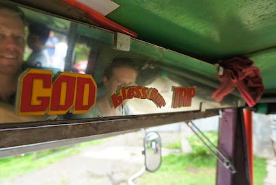
We had learnt during our short 6 week stay in the Philippines that the three B’s were the heart and soul of the people. The population was profoundly Catholic attending church, listening to Christian music, adoring their saints and covering their tricycles in biblical names like Saint James or Christobel as if they were another family member. On the jeepney trip in Palawan there was a sticker on the rear view mirror asking God to ‘Bless our trip’ (because we quickly learnt that the rear view mirror certainly had no other practical purpose). We struck up a conversation with a Filipina in Dapa and when she learnt that we were off a yacht that had come from Australia, she was praising God and blessing us all the way home again! The love of the bible and Catholicism or other Christian denominations was nationwide and added a warmness to Filipino interactions and with us interlopers.


Divine assistance was required for a safe journey!

There was an overt drinking culture, such a stark contrast to neighbouring Malaysia and Indonesia where alcohol is heavily taxed to impede consumption for countries where the national religion forbids it. The national beer brand – San Miguel cost $1 at a bar and as low as 50c from a store in small brown glass bottles that were recycled, you could almost count the years of its service by the scratch marks on the outside of the bottle (a very efficient way to manage the glass needs and drive down the cost). The brewery was another lasting legacy of the Spanish colonialism era, located in a town outside of Manilla and servicing the entire country and all of its remote islands with a beer they proudly consume as few other brands compete with its sale, certainly an easy winner for this enterprise. Next is the Philippine made rum – Tanduay where you can pick up a 1ltr bottle for $1.20, it may be a bit rough but it also cleans the fibreglass very effectively. You can look at the Philippine basketball competition to see the ‘San Miguel Tigers’ battling it out with the ‘Tanduay Lions’, such is the role of alcohol in the society that there is no regulation against advertising and sponsoring sporting competitions.

Basketball has truly been embraced by the Pinoys, a gift from the US era producing a sport loving culture that is evident in even the smallest villages. When we were in Puerta Princessa, the NBA finals were being televised from the USA and our tricycle driver was listening to the broadcast over the radio on his mobile phone, while every shop we walked into had the staff and their extended family glued to every minute of the action. The unfortunate power crash partway through the final quarter almost led the locals to riot. No matter what island or what language spoken, we saw hoops pinned to tree trunks or stuck on walls and kids through to adults almost always shooting hoops. Given the cramped and populous living conditions of the Filiponos, the joy they derived from playing basketball outside was obvious and an escape from the indoor life. Hugh was invited a couple of times to play, but often the rims were lower than his eye height, not a particularly fair match!

Spurs champion of the future? Playing with a basketball stand fashioned
out of welded pieces of metal, held down by large rocks.

So we made our way through our last legs of the trip, upon leaving Port Carmen we noticed that 120lts of fuel had been siphoned from the jerry cans locked securely to the deck. A wave of anger and bitterness came over us, we had only been in Carmen awaiting our sail repair, so we had been most unfortunate. However, we were off on a 100nm overnight sail, bound for Surigao port for an unscheduled fuel stop and our last Philippine stop. We arrived there after a brilliant overnight trip with great wind and none of the nasty fishing obstacles that we had been warned about (such as 4m long metal drums that could do some serious damage to the fibreglass if struck). Surigao port was less than inviting and the town did not have much going on. So fuel stop completed, we sailed another 35nm to the small town of Dapa in Mindanao for our last fresh food stop and to pick our weather window for the 550nm Pacific Ocean crossing to Palau. Another tropical disturbance kept us in port for 3 more days while we waited for a clearer (and larger) window. A typhoon was forming east of Guam and we needed to be confident that it would head north and west, not south and onto us! Thankfully it made its intentions clear enough and we were able to leave, though the wind was high so we prepared for high winds by tying in the third reefing line in the main and leaving bright and early in Monday morning so that we had some good visibility picking our way through the reefy sections exiting Dapa and the Philippine archipelago. Another ocean and a new world awaited us on the other side of the Philippine Sea…the Pacific better get ready, because we were on our way!


Thanks for having us Philippines

3/8/2014

Tuesday, 22 July 2014

Hunkering Down

It was not our intention to be in the Philippines during the typhoon season, it just ended up that way. At the beginning of the season the typhoons historically track more west and north, so that the Philippines is generally skirted and does not receive the full brunt of the typhoons damaging winds and pelting rain. As the season wears on, they tend to track more direct west from the Guam area and the Philippine eastern islands take the full brunt of the tropical force before the storm has crossed enough land to de-power. Having experienced the enhanced monsoon winds from distant typhoon Neoguri/ Florita at Boracay (Cat 5 - 130kt winds), we had now sat out typhoon Rammasun/ Glenda at Port Carmen (Cat 4 - 120 kt winds) and were watching as typhoon Matmo/ Henry blasted north and west of the Philippines. The El Nino year can see a rise in the development of tropical storms or typhoons in this part of the world, as the cyclic warm wind and warm surface water travelling west across the Pacific Ocean builds forming a circular moving motion with the Coriolis effect to culminate in one hell of an exciting* time to be in the region and travelling on a boat. We watch as the systems develop and build, we watch three or four weather forecast systems each day and see what the latest predictions are and whether the speed/ direction/ intensity of the systems are changing for the worse. Every day's decisions are based on those predictions and information about sheltered anchorages could the wind spin around the dial and come from a different direction as the systems move on.

*bloody scary

Grib file showing the wind and rain prediction - the darker the ticks the stronger the wind, the dark grey
patches indicate rain. This swirling pattern is typhoon Matmo/ Henry, just north and east of the Philippines
(the small green box is where we are located)
We intend to leave Surigao to make the 600nm eastward journey to Palau, crossing the Philippine trench, where the water depth plummets from 200m to 5000m. This is likely to be a point where there are strong currents, choppy and sloppy seas and we will be doing it all keeping a close eye on the tropical weather systems and whether we have to make an abrupt southward turn to get to safety.

But right now we are hunkering down as the strong wind systems blow through every day and some squally rains fall. So, what to do? It's not all sunsets and cocktails, I mean it mostly is, but somedays we have to do... chores, bread making, mould cleaning, food stock review and rotation, catching rain, clothes washing. This anchorage has a ground hog day feeling about it. The town ashore has a good fresh food market and some super tasty restaurants dishing up some chicken stews and fried chicken delights (certainly a Philippine favourite). But we don't need to get fresh food everyday. Our friends on SV Shah and SV Shanghaied abandoned us 3 days ago in search of new places and nice water for snorkelling. We had been spending most mornings luxuriating aboard Shah-bucks, enjoying some western style coffees and talking all thing politics and sailing. 

One day was taken up as we endured the epic journey to Cebu city from Port Carmen. Thankfully the sailmaker - Marlon from Hyde Sails, came to the boat to collect our shredded sail, and we caught the 1.5hr long car trip in with him to the Mactan Island tax-free industrial zone to inspect our sail and decide on its future. We had spent the previous two days desperately trying to dry it in the constant drizzle, without it getting ripped up in the rigging when the 20kt gusts blew through. We also had nowhere to lay it out, so the sail loft was going to be perfect. We arrived and walked up to the third floor of the enormous sail factory. A level dedicated to spinnakers and mainsails, a level dedicated to lasers and dingys sails and a level for canvas and shade work. If we have to draw a positive from exploding the spinnaker, it would be that we did it 30nm from one of South East Asia's prominent sail lofts with skilled expertise, modern technology and machinery (and guys who could fit us in at the last minute!). The loft was located in a special tax free zone that enables the businesses to import materials and export products free of Philippine tax and they also have a 7 year income tax exemption period. Such a significant bonus for any business. Though it does seem that a lot of manufacturing is undertaken here and the cheap labour is the driver for international production.

Hugh and Marlon inspecting the various pieces of the sail
(in the background are the huge laser cutters for racing sails)
Thankfully the guys decided that the spinnaker could live again and set to work patching and resewing the seams that had burst. Hugh showed the sail guys the rope burn the spinnaker sock had done to his hand as he had let it go just as the full 35kt wind impact hit him and started to lift him from the deck of the boat, they were very impressed! The might of the wind in a huge sail is very impressive, we were lucky nothing else broke (including Hugh)!

We left the sail loft and were overwhelmed by the amount of construction and activity going on in Cebu city. Guarded high grade condominium developments being erected right next to small shanty villages, isolated shiny malls plotted along a dusty highway with expanses of fields between the next development and guys with woks full of scalding hot oil deep frying anything you want to snack on (chicken wings, hotdogs, strange pink balls of something). Certainly a city of dichotomies, on the one hand lunch in a small bambo hut of fried chicken for 50 cents or buying a new ipad for $1000 next door. It was obvious that there was a great gap between the rich and the poor in this city. But as a result of the development, the city was a dusty, noisy and congested place. 

Our taxi driver took us to the old Fort San Pedro, which apparently has had many uses including as a prison and zoo, but now has some tasteful gardens and interesting photo gallery depicting some of the last 120 years of Philippine society. Momentously, it was here that the Spanish lowered their flag and left in 1898 to leave behind the country as they reluctantly handed it to the USA. We made the short walk inland to the Basillica Del Santo Nino (church housing the famous Philippine statue of baby Jesus - Holy Child of Cebu), where thousands of devoted Philippine Catholics flock to get a chance to see the statue (which is housed in a glass box). The church has a huge outdoor auditorium where the annual Santo de Nino festival kicks off its services on 21 April. The emotion of the people at the church was quite something, and to witness the fascination of a ceramic relic that was purported to have arrived here on Magellan's ship in 1521. Conveniently located next door to the church is the Magellan Cross, a huge timber cross which is said to house some remnants of the cross that the famous navigator and evangelist erected just before he was slain by the chief of Mactan Island, before he was able to garner full Cebu support for a Catholic Philippines (he tried to use the age-old negotiation technique of shooting the locals).

All this touristing had developed in Hugh a hunger and Maccas across the road was the winner. The appropriately named 'Magellan Macdonalds' was sporting all the latest in Macdonalds interior fitouts and I believe that that is truly what Magellan would have wanted upon his discovery and attempted colonisation of the country before his unfortunate (and unsuccessful) negotiation with Chief Lapu-Lapu. 

A quick wander around one of the malls and we were ready to make the long journey back to the boat. 2 hours in a very full bus, complete with a bloke and his fighting cock (they LOVE fighting roosters here), all we were missing was the pet goat to accompany us. We made it back to the boat and collapsed after a busy day of checking out Cebu city. Now to look at the weather prediction and see where we should hunker down next.

22/7/2014